
Summer in Southern Spain is not the time to be hiking, temperatures can get to over 40c after mid-day and it becomes positively dangerous. Therefore most walking groups call a close to their activities over this period and we are no exception, or are we?
The main activities ceased in the middle of June, and even that is later than other groups, with the final few walks being in the wooded and shaded areas.
However some of our members are 'early risers' and Mr John Campbell suggested an early morning group for the summer months that started the walks at 07:00 and were finished by about 10:00 before the sun becames too hot. These now take place on Thursday and Saturday mornings and whilst there is often the intention of planning they appear to end up as voyages of discoveries, which actually bodes well for next season as some fabulous new routes have been found.
What follows are the reports of the walks that John kindly puts on Facebook after each walk along with photographs taken mainly by him but also others;
Madrugistas´ Walk – Saturday 9th September
Although the “Moon walk” was touted as the end of season walk, there was a gap before the “grown-ups” walks begin, so we thought it would be rude not to do another one....
The aim with the walk was to try and tie together a few different walks that we have done this summer. We had a few kms at the eastern end of the Pista Sur to cover, and the easiest way to do that was to go to the big quarry in Mijas – the Cantera los Arenales, and walk up to the Camino de las Sierra – the main fire track on our side of the mountain.
We had a slight setback, as we went to the wrong quarry to begin with. We went to the Cañada de los Canteros. If the truth were known, the fault was mine, but we managed to blame Keith, as he had taken charge of the map.
A bonus for going to this quarry was that we saw three Ibex high up on the cliff. Barbara spotted them with her now supernatural eyesight. They were dislodging stones as they moved about. We were not sure if this was accidental or if they were in effect throwing stones at the dogs, who had spotted them. These are the first Ibex that any of us have seen on the Sierra, so it was a treat.
We eventually realised the mistake and with the help of Google maps, found our way to the right quarry. The path went up beside the quarry and we reached “Pine-tree Pass”, where this track joins the Camino de la Sierra. We joined a couple of kms to the west of the water deposit where we were a week or so ago, so we still have a little of the track to cover to join all the bits together.
On the way up, the still nearly full moon was setting behind the trees, reminding us of the recent adventure.....
Once we gained the Camino de la Sierra, it was odd looking down on "our side" of the mountain. We were above the Silver Mine and looking across to Mount Bernie.
We went west, and Keith took us up a couple of tracks to visit some (or one) mirador(s). The one above the edge of the quarry was quite “impresionante”. We carried on west until we reached the junction with our old friend the Pista Sur. We felt compelled to walk down this until we reached the junction we had been to on a couple of other occasions. So now, we had covered the entire length of the Pista Sur, from Alta Vista, near Alhaurín Golf, to the end where it joins the Camino de la Sierra.
It was mooted that this would be a good one-way walk for a future date, but it would involve a bit of a faff leaving a car or cars by Alta Vista, driving to the quarry, doing the walk, and then recovering the car(s) from the quarry. It was felt it would be worth it, and if all else fails, this might well be the first walk of the next Madrugistas´ season......
We had our meriendas at the junction, and then walked back the same way, without the detours to numerous miradors, so it went quite quickly.
We did 12.9 kms, with a height gain of 548 meters. A very pleasant walk indeed, although it was getting quite hot on the way down, due in no small part to our delayed start with the Ibex spotting.
Madrugistas´ Moon Walk - 6th September 2017
We started walking at 4 am, to time our arrival at the Bola to coincide with Sunrise and Moon set.
The photos are by John C and Manuela – hopefully Barbara will add some later, as she got some good shots.
“Teba John”, who does not “do” early mornings, was convinced that he could consider this as a late night rather than an early morning, so it was nice to have him join us.
We went up the same route that most of us had done 10 days before, when Barbara took us to the Bola in daylight. It was pretty to catch glimpses of the moon through the trees, and a couple of owls hooting added to the atmosphere.
A brief pause was taken at the Fuente and the dogs each scored a sausage, then the climbing started in earnest. The path up from the Casa Forestal is steep enough in places, but at least it was nice and cool. Through a clearing in the trees, we thought we had seen an apparition of the Virgin Mary with a halo. Manuela took a hasty photo and it proved to be Barbara with the moon above her head. I somehow suspect Barbara is going to be stuck with a new nickname for a while though....
We took a breather at the Puerto de Encina and then tackled the steepest bit of the trek. As we got higher, the views down into the valley and Málaga Bay got better with every step, and then suddenly, there was the Bola peeping over the ridge.
On gaining the top, Keith and Cake John each produced a bottle of champagne. It was decided that prudence dictated opening just one on the top, to go with the amazing Bacon Butties that Barbara, the chief catering manager, produced, and some hard-boiled eggs from Keith. Does it get better than this?
There was a cool breeze, which perhaps discouraged the promised naked dancing, but the moon disappeared on schedule as the sun obligingly rose on cue.
Back down at the Puerto de Encina, it was decided that it would be rude to take one of the bottles of champagne home, so it was duly breached, to accompany chocolate cake, as only Cake John can make it. I have to say there was a fair amount of giggling caused by the second bottle, but I promised not to say that Barbara and Manuela were responsible for all or most of giggling, so I will not mention it.....
From there we ambled back down to the cars and drove into town, to meet up with our illustrious leader himself, who came to Dani´s Bar to greet us. After what we had eaten on the walk, nobody could face a bacon butty at the bar – that is a first for a Madrugistas walk!
Madrugistas´ Walk – 2 Sept 2017.
The forecast was, not to put too fine a point on it, a little “iffy”, but we decided to go anyway. We started from the entrance to the gun club and headed up the Camino de la Sierra – the main track that leads up to Puerto de Encina.
Almost as soon as we started up the trail, the clouds began to lift and the sky looked brighter. As we got a bit higher, the clouds tumbling over the top of the Sierra were pretty spectacular. It is quite a steady pull up the track, but soon enough we got to the water deposit at the crossroads above the silver mines. We stopped there for the merienda. That was our highest point at 688 meters.
There was a surprising number of bikers and a few walkers, all of whom stopped at the water deposit. Cake John was regretting that had no raffle tickets to sell.....
Once the merienda was over, we headed on down to the track to the Silver Mines. Below the Silver Mines, we cut off to the east, along the smaller track that crosses the Llanos de la Plata. By this time the sky was really breaking up and the sun appearing more and more.
We got back to the cars, having done 13.2 kms, with a total climb of 517 meters. Then we were faced with the awful dilemma of where to go for a bacon butty. In the end we elected to go to the Venta Pedro Vazquez. The kindest way to put it would be to say it was a tad disappointing. To be fair to them, it was getting on for noon, but they were out of Pitufos and it is hard to make a convincing bacon butty from ordinary bread – so at this point, they are 5th equal with La Peñita....
It was all good training for our next walk, on the 6th, which is going to the Bola by the light of the full moon, to watch the sun come up from on the top.
Madrugistas´ Walk 30th August
Fuente de la Adelfa and more Pista Sur
Fuente de la Adelfa and more Pista Sur
The main ideas for this walk were to check out parts of the Rutas de las Cañadas, and Fuente de la Adelfa, as well as travel a bit more of the Pista Sur.
Because it was going to be a one way walk, or a very long round trip, we left a car below the Hermitage, then went back to start from T3 and the beginning of the familiar Ruta de la Cuz de las Misión.
At the first main junction, we headed up the Ruta de las Cañadas, on a new (to us) track. We were impressed that this track and the subsequent Fuente de la Adelfa have both been renovated within living memory, and for the most part, were in very good shape.
Once we gained the Ruta de la Adelfa, it was deemed time for the first merienda. Cake John produced a rather delicious orange cake. Keith has developed a special technique for snagging a good part of the piece below, when he takes his piece – this was noted by all for future use.
We eventually reached the Pista Sur – this is the main fire trail that is about half way up the Sierra. Walking east, the clouds pouring over the ridge were quite spectacular. We carried on east, to reach the lookout we got to last time we were up here, and did the “family photo” on the top. Now we “have” to cover the last stretch of the Pista Sur to where it meets “our own” Camino de la Sierra. There is a cunning plan in place, but it needs a bit of a recce as to where we can park – watch this space 
After merienda number 2, we dropped down the same route we took last time, to the quarry and then to the little shrine. We have heard on good authority, it is extremely bad luck to pass this shrine, without a pause to eat a Ginger Nut. Not wanting to risk the wrath of some unknown power, we dutifully obliged, with merienda number 3.
From there it was down to the car by way of the hermitage, and on to the BP garage for a “you-know-what”.
We were a bit surprised that we covered only 8 kms, but with a total up of 442 meters. By the time we had had the semi-compulsory bacon butties, we probably ate more calories than we used, but we all voted this walk one of the best – close to a perfect 10.
Madrugistas´Walk – Saturday 26th August 2017
This was called the “BTTB” walk – Barbara to the Bola, as she was a small bit miffed that she had not been able to come the week before, when we had ended up at the Bola.
It was a very select group today, as familial duties interfered with a few plans. We left before dawn, to try and get well on our way before it got hot. We started walking at the Camino Forestal and followed the well-trodden path up to the Fuente. We were there just before dawn and were pleased to see it is still running. Not as strong as before, but at least there is water running.
From there it was up the steep stone steps to the Casa Forestal and then up the rocky path to the Puerto de Encina – Oak-tree Pass. By the time we got up there, the sun was well up and already we could feel the heat, so we did not linger, but pressed on up the track to the Bola.
That track is very sandy in places, so I presume this was once beach-front property a zillion years ago – no doubt Teba John will set us straight. Although this track is quite steep, and a bit difficult in places, it is a heck of a lot easier than the route we took last week.
As we were huffing our way up the steepest bit, we were shamed by a guy who ran past us, carrying a bike. Huh... Well, at least Sancho could have raced him to the top, but we certainly could not.
Once we crested the final ridge, the Bola was in sight, not too far away, so that spurred us on....
On the south side of the Sierra there were lots of clouds, but they were well below us, and the view was actually quite special. On the north side, the valley and Málaga Bay were shrouded in mist, with the small mountains poking their way above the mist. The Benalmádena towers were also fighting to stay above the clouds.
We lingered for at least half an hour, enjoying the views and plethora of biscuits Eventually we decided we had better heed the siren´s call of impending bacon butties, and head down the hill before we got too stiff to move....
The distance was 12.01 kms, and the total “up” was 761 meters, so it was a fair walk, but actually not as tiring as the Mijas walk last week, and certainly much easier than the previous route to the Bola.
While we were digesting the bacon butties at Dani´s bar, we discussed the impending end of the Madrugistas´season, when Al will declare the “Grown-ups” walking season open again. We feel we should go out with a flourish, so we are planning a very early start (4 am!), perhaps on the night of the full-moon, and go up in time to have breakfast on the top and watch the sun come up..... Watch the upcoming emails if you feel an over-powering urge to join us.
Madrugistas´ Walk Thursday 24th August
This turned out to be the shortest walk of the Madrugistas´season, but it sure did not feel like it. The Mijas Town Hall rate the track we went up as a “Medium”, but to me it felt like a “Well done”.....
Right from the start, we were going up, and at times quite steeply up, as we followed the track “Cañada Gertrudis” I have no idea who was Gertrudis, but she must have been pretty fit if she went up and down her track.
As we started up the track, the Hermitage above us was still lit, and looked good peeping out from among the trees. Once we began to climb, the sun came up over the mountains to the east, and Mijas pueblo began to wake up below us. We gained height very quickly and the path was quite rocky and steep in places.
Pretty soon we could see the Pista Sur above us – the main fire track crossing the mountain. There was a very steep and rocky bit before we could reach the Pista, but the effort was worth it. There was a bit of a plateau there – maybe a helicopter landing spot, with great views in all directions.
After the obligatory “family photo” we began the descent. We went a little way down the Ruta Puerto Malaga, until we reached the track that drops down to the quarry we visited last week – the Ruta Cantera del Barrio – the Neighbourhood Quarry!
Once we reached the quarry, we were back onto the track we had been on last week – the Ruta de la Cruz de la Mission. On that track, we went east, until we reached the little shrine, which last week became nicknamed “The Ginger-nut Shrine”. We felt obliged to walk up the short flight of steps to the shrine, and it would have been rude not to have a Ginger-nut or three....
This was where we had turned back last week, but this week we had left the car just below the Hermitage, so we dropped down the track to the Hermitage and on downwards to the car.
On the way down we saw a very strange plant. It was growing out of a very large bulb, about the size of a pretty big onion. If anybody knows what it could be, Barbara would especially like to know....
From there we beat a circumspect retreat to the BP garage for a very well deserved breakfast of the best bacon butties in the land.....
So we did a paltry 5.1 kms, with a climb of 359 meters, but, as they say in American Football, they were hard yards that we did........
Madrugistas´ Walk – Saturday 19th August
This turned out to be more of a Thursday walk than a Saturday one! It was perhaps the hardest one that the Madrugistas have done, with 844 meters of “up”. Unequivocally at nearly 15 kms it was the longest, but arguably, it was perhaps the best....
We walked up from the parking, past the “dog prison” and then went straight on up the dry river valley – the Aroyo del Tejar. It is a steady pull up the valley, past the “Hidden Quarry” to the junction where the path goes left, up the side of the valley to “Manuela´s Crossroad.”
At the junction, we debated briefly if we should go left, to the Camino de la Sierra, or be brave, and carry on to see if we could get to the ridge at the head of the valley. The dogs had already decided that was the way we should go, so we did....
The track was steep and rocky as we inched up the side of the river valley. The reward was that the views got better and better the higher we got. Enthusiasm was perhaps slowly diminishing, when we saw the Camino del Tejar at about our height, but the other side of the deep valley. This is the road that the workers drive up to reach the Bola.
Again, the dogs were ahead of the game and we followed them onto the ridge, which had been our target. Now we had to decide if we should brave the steep and rocky track back down, or traverse the ridge and go back down the road. This seemed like a better plan.
As we got closer to the road, we spotted the Bola peeping through the trees, so we were pretty high. When we joined the road, the Bola was quite close, so we agreed it would be rude not to go the last little bit, and pay homage to the Bola. We were surprised at how many people we met when we got close to the Bola; about a dozen hikers in small groups and about the same number of mountain bikers.
None had come up the route we took, which has to be the second-hardest way to get to the Bola. The hardest must be the route Cake John took a few weeks ago with a couple of Spanish guys - straight up the fire-break.
We could have dropped down to the Puerto de Encina, but we chose to walk down the Camino del Tejar, which was a bit further, but not as steep.
By the time we got back to town, it was getting a bit late for bacon butties, so we had a swift drink at El Molino and headed for home. I think everybody, humans and canines alike, were tired little explorers at the end of that, but we were all happy to have found a new track, and a bonus visit to the Bola.....
Madrugistas´ Walk – Thursday 17th August.
We drove to just beyond the Venta los Condes and then we walked up the T3 trail – Tony´s Trail Two. We had planned to go up the main fire trail – the Pista Sur, but there was a thick bank of fog over the sea, and only “Cake John” and I had been on the lower trail, the Cruz de la Mision, so we elected to go along that.
We had enjoyed it the previous time, as the trail winds it´s way through the newly planted mixed forest, and we remembered the perfect picnic spot at a small mirador. When we got to the mirador, it would have been rude not to stop, so we did, and guess who produced some delicious orange cake for all? There was a piece left over which the dogs shared and enjoyed as much as we had.
This time we got further east, passing through a large and deserted quarry. It must have been quite a project getting the cut stone off the mountain. We kept going east, until we were above the town of Mijas. There was a small shrine on a ledge above the track, which looked like a perfect place for a second picnic. The dogs took a shine to Barbara´s ginger biscuits, so they cannot have been too far out of date.
Next time we will come up the track from town, and then we have another three routes to explore just in this small area.
On the way back, we took a brief look at a “horno de cal” - a lime kiln. Dredging back to my high-school chemistry, they burn lime stone (Calcium Carbonate) in these ovens, to make Calcium oxide, or Quicklime. Quicklime is then slaked with water, to give Calcium Hydroxide, which since time immemorial has been used as a disinfectant and for “white-washing” houses. Normally they preferred to burn oak in the kilns, so most likely this area of forest had been “Encina” trees, before the big fire.
We crested the last hill on the way back to the car, just as it was starting to get warm. From there, the obvious thing to do was to go to the BP garage for the finest bacon butties in the land.
We walked just a taste over 8 kms, and the total up was only 243 meters. The going was not that easy, and in truth, it felt we had done more than that, so we felt that breakfast was well deserved.
Madrugistas´ Walk Saturday 12th August
This had some elements of a Thursday walk, since we were trying a new (to us) track in another attempt to get to the top of Tajo del Caballo, on the Sierra de Mijas.
We started from the Camino Forestal and went up to the Fuente, which appears to be flowing a little less than last week, but still flowing quite well. From there, we went up past the Casa Forestal and up the track towards Puerto de Encima. However, when we got to the crossroads, where the track drops down to the Secret Mine, we took a left onto the new-to-us track. It was here that the sun started to rise and it was a pretty sight, seeing the Mountains of Málaga emerging through the low clouds. This alone was voted worth the early start.
To begin with, it looked pretty overgrown, but soon became a fairly well-trodden track up the hill. We wended our way up through the trees to emerge onto a broad fire-break. At the lower end there was a very prominent rocky outcrop, so we had to go and climb that, if only to prove Paula is not the only one who can perch on unusual rocks and things.
As to be expected, there were great views down onto Grande and into the valley. The track continued onwards and upwards, and when it appeared that the only way was up the very steep fire-break, Keith voiced the opinion that a bacon butty was more appealing than scrambling up there, so we beat a tactical retreat.
Looking at the Open Street View map, the track actually skirts this climb, and we should have seen the track going to the east from where we stopped, but we did not. I need to learn how to make a GPX track and mark this path, then we can have another go..... Surely it will be third time lucky?
We were actually pretty close to “The Bola”, so before Alan calls it a day for the Madrugistas and reopens the official walking season again, we should perhaps do a small excursion up there from this route.
We went back down the same way, and in total we walked just about 8 kms, with a total “up” of 492 meters. Our highest point was 885 meters.
To finish the excursion, we felt obliged to continue with our very scientific survey of bacon butties. We went to Bar Dani´s and they were voted into third place, but still considerably behind the leaders.
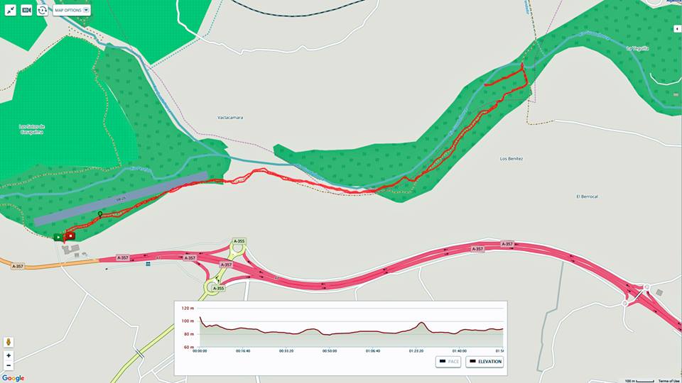
Madrugistas´ Walk. Thursday 10 August.
The forecast was warning of thunder squalls this morning, and having seen on the news, the stories of the tennis-ball-sized hailstones in Navarra on Wednesday, we decided to stay off the mountain and go elsewhere. We were a bit thin on the ground, as a couple of regulars are still away, and Manuela, the Chief Entertainment Officer is busy baby-sitting for a while.
We decided to go for an amble, as supposed to a Ramble, along the banks of the Guadalhorce, and very pretty it was. First thing, the sky was totally clear and then a few clouds started to appear as the sun came up. There was an almost-full moon hanging over the river and a marvellous golden light as the sun appeared.
We ambled along from the little airfield, going first through the eucalyptus woods, before wandering down to the river bank. We saw all kinds of birds, from ducks and herons to some stork-like birds, all fishing in the river. We were pleasantly surprised at how much water is still flowing.
Deeta is a real water-dog, but Sancho does not normally like getting his feet wet. Deeta was straight into the river, and eventually he persuaded Sancho to join him. They kept us amused with their antics chasing each other up and down the river.....
We wandered back the same way, and the clouds were building, especially over the Sierra. We decided we had done the right thing by not venturing up the mountain.
Although we had done just shy of 7 kms, with a total height gain of a paltry 29 meters, the gathering clouds persuaded us that we should go and do our duty with testing more bacon butties. We went to Caravajal on the Variente. They have taken over third place from La Peñita, but still fall far short of the favourites.
We got a few spots of rain as we arrived home, but no sign of the threatened thunderstorm. A very pleasant way to start the day though......


Saturday 5th August.
For various reasons, and a forecast of 35 degrees for noon, left
us with just the hardest of the hardcore, and even then, “Cake” John and Deeta
had to bail out half way up as they were on a hot date for 10am. They came with
us to just above the Fuente. It was good to see that the Fuente is still
running quite well – so much better than last year when it was dry for at least
nine months.
Once John and Deeta beat a retreat, the rest of us, which boiled down to Sancho Panza, Keith and me, carried on up the hill, on the track from the Casa Forestal to Puerto de Encina – Oak-tree Pass.
The tentative plan had been to go up Tajo del Caballo. However, the sun was getting hot, there is little shade on that peak, and I knew from a previous visit there, it is not an easy path, over large and broken rocks. So when we put it to the vote, only Sancho was in favour of tackling it. We were already at 970 meters, a scant 180 meters below the Bola, so we decided to call it a day, and walked down the Camino de la Sierra, and back to the car at the end of the Camino Forestal.
That was pleasant enough, with good areas of shade, and of course the exceptional views of Alhaurín el Grande.
We walked 12.2 kms, and the total “up” was 636 meters. Looking at the Openstreet map of the Sierra, I can see a different route onto the Tajo del Caballo, so maybe when it cools a little, we can have a look at that, and see if that is easier than the one I have been up before.
We thought it only right to test the bacon butties at La Peñita, but they fall sadly into third place in the bacon butty challenge.
Thursday 3rd August. T3 – Tony´s Track Two.
In true Thursday style, we did not go where we intended, but
found, thanks to Tony, and even better route.
Things did not get of to a propitious start as we could not find the beginning of the intended track. Tony´s instructions last week, were, not to put too fine a point on it, just a tad vague. So we did spend a wee while wandering up and down the main road, looking for what might appear to be the right track.
After a kilometre or so, we had narrowed it down to three possibles. Manuela nipped off to the bar, not for a heart-starter, but to ask the people there if they knew which was the way up the mountain. She was met by slack-jawed wonderment as to why anybody would be wanting to walk up the mountain at all, let alone in the middle of summer, so we were non the wiser.
Eventually we chose the middle one of the three, and by a quirk of fate, that proved to be the right one, because before we had gone a hundred meters, whom should we see walking down the track, like a wraith emerging from the mist, but Tony himself. He came armed with a bunch of maps from the tourist office, and like a good tour-guide, he walked up to the beginning of the track that he suggested we take, before disappearing to run his errands.
He suggested we take the track called the Ruta Cruz de la Mision, so we did, and what a delight it turned out to be.
It winds up through mixed forest to a path that clings to the face of the mountain, sometimes a little precariously it seems, about half way between the main road and the Pista Sur, which was where we were the previous week, and had been our intended destination.
This track is very interesting indeed, with lots of views and miradors, and for the most part, enough shade to guard against the fast rising sun.
We walked to a ridge above Mijas, before beating a retreat, to make sure we were into the bar before it got too hot. Because of the abortive faff at the beginning, we covered just 7.6 kms, with a total “up” of 230 meters. That is one of the shorter walks we have done, but it has shown us a myriad of new tracks that we still have to explore, so we will be back in this area next Thursday.
If only there had been a supply of dodgy biscuits, this walk would have probably scored a perfect 10. As it was, we had to make do with bacon butties at the BP garage – their bacon butties, if made with a pitufo “omega”, lead the bacon butty challenge at this point......
Saturday 29th July
Above the “Secret” Mine
There was a fair amount of “up” on this one, but despite a bit
of moaning from most of us in turn, it really is not that steep, and for the
most part, on reasonable tracks.
We did 10.4 kms, with a total “up” of 459 meters, to reach a maximum height of just shy of 750 meters. Our route took us straight onto the Sierra and up “Rocky Road” to the area of the mine.
We followed the track up past the mine onto the ridge. It was still quite misty below as the sun was coming up over Málaga Bay. Despite the mist, still good views.
We carried on up to the track that runs between the Fuente and Puerto de Encima. We turned left and followed the track down to the Casa Forestal, where we took a short break in the shade. Deeta bagged pole position, but there was still enough shade for us.
From there it was down to the Fuente. We were happy to see plenty of water still running at the Fuente – so much better than last year. We re-filled our water bottles and carried on down to the bar El Molino for the now obligatory bacon butties.
It is safe to say, we all enjoyed the walk, and the bacon butties.....
Thursday 27th July
We had another walk along a new (to us) track on the south side
of the Sierra. We drove close to Alta Vista on the Mijas road, and walked up
the track that let us join the track from last Thursday, when we walked over
the Puerto de los Lobos. I wonder how long it has been since there was a Lobo
on our mountain?
The track we joined is the Pista Sur. It is obviously an
important fire trail, as we could see signs of recent work to keep it clear. It more or less follows the
Mijas road, but about half way up the mountain.
We had been walking about an hour
when, to our surprise, we came across a hot and rather sweaty Tony. He had
walked up the trail from near Venta los Condes. This track will possibly become
known as T3 – Tony´s Trail Two. We intend to try that next Thursday so we can
go yet further eastwards on the Pista Sur.
After the obligatory photo, Tony
carried on towards Alhaurín while we followed the track a little further to the
east. Just before we turned back, a curious thing happened – I am not sure if
it was the altitude, the rising sun, or just plain hunger, but we all began to
smell food. Slightly stale food, but food non-the-less. See photo number 5 as
to what happened....
We headed back the same way to
where we had parked. We covered 9.5 kms, with a total “up” of 407 meters. Most
of this was climbing up to the Pista Sur from the Mijas road. It was not too
steep though and on a reasonable surface. All in all, yet another pleasant
walk.....
Saturday 22nd July. To the Pee Mine and
the gun club.
As promised, this was an easy walk with not too
much up at all. On the pic of the track, ignore the start point - I did not
start in the forest but forgot to turn on the Map My Walk. Who said
"plonker"?
In total we did 11.3 kms from the car park to the bar.
It was cool and fresh as we walked along the main fire trail. We stopped at the Pee Mine for those who had not seen it before to make a visit.
By the entrance to the mine, there had been a rock-fall and that has exposed what looks like an entrance to yet another cave. A few rocks will have to be moved, but it looked like somebody thinner than Cake John could wriggle in there - where was Teba John when we needed him - fast asleep was the answer.....
😴
We carried on along the main track to the overlook at the Gun Club. Although the summer haze was setting in, the views were still great and it was especially pretty looking into the sun over Málaga Bay.
After taking the "family pics" we returned the same way, to partake of the now-obligatory bacon butties at El Molino.
All agreed it was a very nice walk and a pleasant way to start the day
In total we did 11.3 kms from the car park to the bar.
It was cool and fresh as we walked along the main fire trail. We stopped at the Pee Mine for those who had not seen it before to make a visit.
By the entrance to the mine, there had been a rock-fall and that has exposed what looks like an entrance to yet another cave. A few rocks will have to be moved, but it looked like somebody thinner than Cake John could wriggle in there - where was Teba John when we needed him - fast asleep was the answer.....
We carried on along the main track to the overlook at the Gun Club. Although the summer haze was setting in, the views were still great and it was especially pretty looking into the sun over Málaga Bay.
After taking the "family pics" we returned the same way, to partake of the now-obligatory bacon butties at El Molino.
All agreed it was a very nice walk and a pleasant way to start the day
Thursday 20th July 2017
We had a very nice walk on yet another new (to us) path on the Sierra. We started on the edge of the forest, near the BP gas station, and followed the recently marked route towards Mijas.
It is signed as part of the Gran Senda de Málaga, which is the GR249, but looking at the map, it is actually the GR 92E. Either way, it was a very nice walk. Although there was a fair bit of "up", none of it was too steep and we were well shaded. Our total height gain was 466 meters, on a walk of 8.4 kms.
For most of the route we were between the Mijas-Coín road and the road to the Bola.
Once we got over the ridge, we had great views across to Africa and along the coast towards Gibraltar.
Most of the way was on a narrow single-track path, but the last bit, before we turned back, was on a wider track that looks to drop down to the Mijas road near Alta Vista.
Nest week we will park near Alta Vista, rejoin this wider track and see if we can get above Mijas.
At the end of the walk we drove back to El Molino, for the now obligatory bacon butties. Make the whole thing worth while.
Saturday 15 July 2017
This was just 8.4 kms but with a climb of 355 meters. Most of this "up" was in the first 45 mins.
Very strange weather today - after the very hot weather, today
we got low clouds and high humidity, but not too bad for walking.
We went up past the dog prison
and then along to the beginning of the road up to the “Bola”. Near the
beginning of this road is a chain, to stop people driving up, and just past the
chain is the shortcut that Sancho discovered last week. We followed him up the
sometimes steep and occasionally rocky path until we got to Tony´s Track – so
named as Tony showed it to us a while ago.
It is officially called the
Sendero del Conde – the pathway of the count. I have no idea which count got
the path named for him, so perhaps it should be Count Tony´s Track?
This path is a delight – little
bits of ups and downs and a few fallen trees to negotiate. You will see in the
photos that Cake John did the gentleman act and held up a tree for Barbara to
pass beneath.
The highlight of this track is the view above the water tower, however, today, we were well in the clouds – you can see what we saw, and I put in one from last week to show what we should have seen.
The highlight of this track is the view above the water tower, however, today, we were well in the clouds – you can see what we saw, and I put in one from last week to show what we should have seen.
As we dropped down towards
Alhaurín Golf, we came to the first of several new signposts that have been put
up in this past week. Several are marking the Gran Senda de Málaga – the Great
Málaga Path, that runs right around the province of Málaga - http://www.gransendademalaga.es/en/etapas/
We stopped at a large cairn that
marks the route towards Mijas. This is part of stage 32 that runs from Ojén to
Mijas. It is 32.8 kms, which is perhaps beyond even the most ardent of the
Madrugistas, but next Thursday we are planning to start from that end of the
Sierra and follow the Gran Senda part way up the hill towards Mijas and see
where it goes.
From there we dropped down onto
the main fire track and returned to El Molino, for what we felt were
well-earned bacon butties.......
Thursday 13th July 2017
Being a Thursday walk, we felt at liberty to change plans along
the way. Discretion, valour and chocolate cake all came into the discussion, as
did the fact that the forecast was talking of some 36 degrees by noon.
We went as planned, past the dog prison and the hidden quarry, then up the path beyond the quarry. When we got to "Manuela´s Junction" we had a brief discussion as to whether we should turn right and go to the ridge near the "Bola", or go left, find a shady spot, and eat chocolate cake - no guess as to how the vote went.
Cake John had not only made a cake specially, but he carryied it all the way up the mountain in a cold bag, with two blocks of "blue ice" to keep it at it´s best. Once we were settled, he produced napkins and forks for all - all that was missing was a table and some chairs, but we managed. So who misses Paula´s out of date biscuits now?
Once the picnic was over, we carried on as last time, to join the Camino de la Sierra, by the chain, before dropping down past the Secret Mine, Tina´s Trail and into El Molino for what is becoming the traditional bacon butty.
It was only 9 kms, but we did get up to 755 meters. It was getting warm towards the end, but I would say we all enjoyed the walk, and especially the cake. Whose turn is it next week??
Saturday 8th July 2017
We walked up "Tina´s Trail" and then along to the Fuente. While walking on the top road, we saw the track of a very large snake in the sand. It must have been a big one, as it left two parallel tracks close to half a meter apart.
After the obligatory pause at the Fuente, and despite Manuela´s request for no photos, we did the group shot.
From the Fuente, we walked east, almost to the area of the Chains.
We turned back near the last of the shade trees, and headed back to the Fuente, down to the lower road and on to El Molino, for the best bit of the day
You can see on the details map, we did 12.4 kms, with a height gain of 442 meters. We burned about the same number of calories as in the bacon sandwiches
Subterranean Saturday - 1st July 2017
For this walk, we stuck to routes known to “Camera John” and
Sancho Panza, but of the rest only “Cake John” had been to the secret mine
before...
Once we were onto the Sierra, we went up Tina´s Trail and were rewarded by a fantastic view across the valley as we crossed the fire break. It was a remarkably clear day.
Since there is no real path to the secret mine, I guess one reason why it is still secret, we had to go “off piste” for a hundred meters or so; Barbara valiantly took the lead and forged her way through the brush.
After exploring the mine, we stopped for a drink and a small break. Sancho Panza and Deeta kept us amused by playing tag around a tree.
After braving the crossing back to the path again, we dropped down to the end of Rocky Road and went down there to the main fire trail. Instead of returning along this, we dropped down the ravine to the caves. Several of them are quite big and we had a look into the biggest. There were bats that appeared to be nesting, so we did not linger so as not to disturb them too much.
We continued down the ravine to come onto “Camino Cholesterol”, which we followed back into town, and were in the bar almost exactly at 10.
Our route was 7.3 kms, the total height gain was just about 300 meters. The highest point was the mine, at 624 meters.
Alan will be dissapointed to hear I did not fall on my ass this time.
Thursday walk of Discovery 29th June.
We walked up the ravine to the “Hidden Quarry”, looking for a
track that we had been told about the week before. Eventually we found two
small cairns marking the path up the side of the ravine.
It was a steady climb up the hill until we came to a T juntion. Manuela
insisted that we went to the right, so we did.
After a km or two, it became apparent we were on our way to Mijas – we will save that one for another day. While we were contemplating what to do, “Camera John” kept the crowd amused by doing a back flip into a gorse bush. “Cake John” was eager to use the contents of his new First Aid kit to staunch the blood, but I have to say that I felt that fifteen euros was perhaps a tad excessive for two Band Aids....
We retreated to the T junction and took the other path. This quickly led us above the quarry itself. It then zigged and zagged up the hill, and sure enough, we reached the Camino de la Sierra, just below the chain, right on the hairpin bend that looks down on Alhaurín el Grande.
We walked down the camino to “Rocky Road”, down that to the lower fire trail, and into the bar just before 11.
We walked 10.9 kms, the total height gain was 650 meters and the highest point reached was 878 meters. This could easily be a Saturday walk in the future.
Photo's only for the first of the early morning walks Saturday 24th June 2017


